What Does the Kp Index Mean for Drone Pilots?
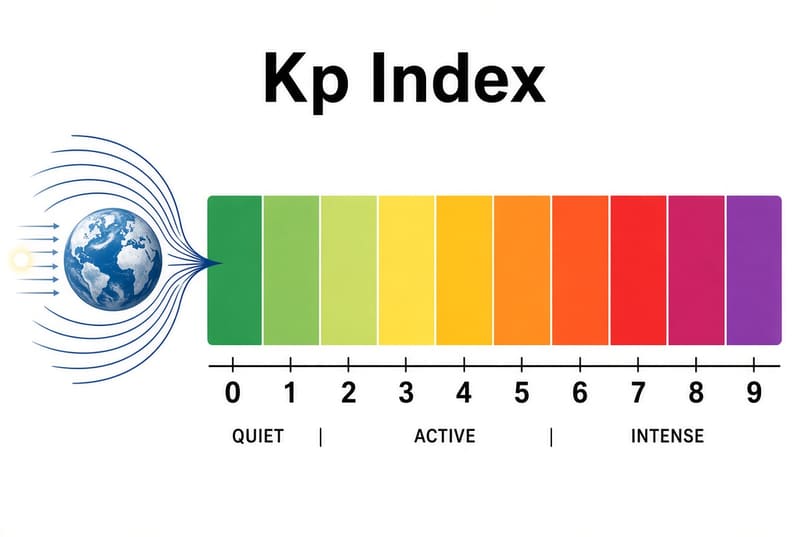
The Kp index appears in most drone-weather apps right next to wind and visibility, as if it were the same kind of number. It isn't. Wind is measured at your location and can knock a drone out of the sky; Kp is a single global number describing how disturbed Earth's magnetic field is. It is worth checking, but for most pilots on most days it should change how you fly, not whether you fly.
What Kp measures
The planetary K index (Kp) runs from 0 to 9 and summarises geomagnetic disturbance across the whole planet. NOAA's Space Weather Prediction Center derives the official value from a network of ground magnetometers and publishes it for each 3-hour period. It rises when the solar wind, and especially bursts of it from the Sun, disturbs Earth's magnetosphere.
Two properties matter for pilots:
- It is global. The same Kp applies whether you fly in Norway or Kenya, even though the effects are very different in those places.
- It is a 3-hour value. A single reading describes a 3-hour window, which is why the number changes in steps rather than smoothly.
NOAA classifies geomagnetic storms on a G-scale that maps directly onto Kp:
| Kp | NOAA storm level | Typical description |
|---|---|---|
| 0–3 | — | Quiet to unsettled |
| 4 | — | Active |
| 5 | G1 | Minor storm |
| 6 | G2 | Moderate storm |
| 7 | G3 | Strong storm |
| 8 | G4 | Severe storm |
| 9 | G5 | Extreme storm |
How a geomagnetic storm reaches your drone
GPS: through the ionosphere
Geomagnetic storms do not jam GPS signals directly. They disturb the ionosphere, a layer of charged particles roughly 80–1,000 km up that every satellite signal passes through. During a storm the ionosphere becomes uneven and changes quickly. Signals are delayed by amounts the receiver cannot fully predict, and in stronger cases they flicker in strength — an effect called scintillation.
Most consumer drones use single-frequency GNSS receivers, which correct for the ionosphere with a simple model. When the ionosphere is disturbed, that correction is less accurate, so the position estimate wanders more than usual. In strong events, satellites can drop out and the receiver may struggle to keep a solid lock.
Where this happens matters as much as the Kp number:
- High latitudes (Scandinavia, Iceland, Alaska, Canada, southern New Zealand and similar) feel storm effects most, because the disturbance is concentrated around the auroral zones. A Kp 6 can be noticeable here.
- Mid-latitudes (most of Europe and the continental US) usually see only small effects until storms are strong (roughly G2–G3 and above).
- Near the magnetic equator (about 20° either side), scintillation is common in the hours after sunset, especially around the equinoxes and near solar maximum — for reasons largely unrelated to Kp. A low Kp there does not guarantee a clean GPS evening.
Compass: a much smaller effect than often claimed
Many articles say a high Kp makes drone compasses unreliable. The physics says the effect is usually small. Earth's magnetic field at the surface is roughly 25,000–65,000 nanotesla. Even during a strong storm, the field at mid-latitudes typically changes by a few hundred nanotesla — a heading change well under a degree. At high latitudes during severe storms, changes can be larger and reach a few degrees.
The "toilet bowl" effect — a drone circling slowly instead of holding position — is almost always caused by a compass that is poorly calibrated or sitting next to metal, magnets or electrical interference. A geomagnetic storm is rarely the cause. Calibrate the compass as your manufacturer recommends and take off away from cars, reinforced concrete and metal structures.
What each Kp level means in practice
- Kp 0–3 — quiet. No measurable effect on typical flights. UAV Meteo rates this Good.
- Kp 4 — active. Usually no noticeable effect outside high latitudes. UAV Meteo starts showing Caution above Kp 3, as a prompt to look at your GNSS status, not a reason to stay home.
- Kp 5 (G1). Small position wander is possible at high latitudes. Be more careful with automated missions that depend on accurate positioning — waypoint missions, mapping grids, orbit modes.
- Kp 6+ (G2 and above). Real risk of position drift and satellite dropouts at high latitudes, and possible effects at mid-latitudes as the level climbs. Postpone precision work (mapping, inspection close to structures) and keep flights close enough to fly manually if GPS hold degrades.
How UAV Meteo rates Kp
The Kp Index card leads with NOAA's official 3-hour planetary Kp and shows NOAA's faster 1-minute estimate as a smaller "Live" value. The rating uses the official number:
- Kp 3 or lower: Good
- Above Kp 3: Caution
Kp can never make the overall status Not suitable on its own. It belongs to the group of informational conditions (with humidity, UV, air quality, wind shear and cloud cover) that are capped at caution, because none of them directly limits whether the aircraft can fly at your location. The How UAV Meteo works page explains exactly how core and informational conditions combine into the banner status.
The trend arrow on the Kp card compares the current value with NOAA's next 3-hour forecast window, so you can see whether activity is rising or easing.
What to do when Kp is high
- Check the GNSS status in your flight app before takeoff. The number of satellites and the position accuracy your own drone reports are direct, local measurements — more useful than Kp. UAV Meteo's GNSS card shows an estimate of visible satellites for your location.
- Wait for a solid lock. Don't take off until the drone has a stable home point.
- Fly closer and lower. Keep the aircraft where you could fly it back manually if position hold degrades.
- Be ready for attitude mode. Know how your drone behaves without GPS position hold — it drifts with the wind, so plan your reaction.
- Delay precision missions. Mapping and survey accuracy is the first thing to suffer; if the data matters, pick a quieter window.
What drives Kp up
- Coronal mass ejections (CMEs) — large eruptions of magnetised plasma from the Sun. An Earth-directed CME usually arrives one to three days after it is seen, which is why storms can often be forecast several days ahead.
- High-speed solar wind streams from coronal holes produce milder, often recurring activity roughly every 27 days as the Sun rotates.
- The 11-year solar cycle changes how often storms happen; high-Kp days are more frequent around solar maximum.
Kp and the aurora
Aurora forecasts use the same Kp index, and a higher Kp means the aurora can be seen further from the poles. The thresholds are different, though: a Kp that is exciting for aurora photographers at mid-latitudes is often irrelevant for GNSS at the same place. If you are planning to film the aurora, plan for the conditions that come with it — high latitude, darkness, cold batteries — as much as for Kp itself.
FAQ
Should I cancel a flight because of a high Kp?
Rarely on Kp alone. At mid-latitudes, only strong storms (G3 and above) are likely to affect a typical flight. At high latitudes, Kp 5–6 is a good reason to postpone precision or long-range automated work. In every case, check your drone's own GNSS status before takeoff.
Does Kp affect my video link or remote-control range?
No. Kp describes geomagnetic disturbance. Video links and control radios work on different frequencies and are affected by interference, obstacles and antenna orientation, not by geomagnetic storms.
Why does UAV Meteo show two Kp numbers?
The main number is NOAA's official 3-hour planetary Kp, which is stable and matches what most other apps show. The smaller "Live" number is NOAA's 1-minute estimate, which reacts faster but is noisier and preliminary. The rating uses the official value.
Is Kp relevant if I fly near the equator?
Kp itself matters less there, but GPS can still be disturbed in the evening by equatorial scintillation, which Kp does not capture. Check your drone's GNSS status before post-sunset flights.
Where can I see Kp forecasts further ahead?
NOAA's Space Weather Prediction Center publishes a 3-day geomagnetic forecast and alerts for incoming CMEs. UAV Meteo's 7-day forecast view also shows the highest forecast Kp for each day.
Related guides: how to read a weather forecast before flying and why weather apps show different forecasts. The Weather diagrams page shows the Kp timeline for the coming days.
Sources
- NOAA Space Weather Prediction Center: Planetary K-index, NOAA Space Weather Scales, Ionospheric Scintillation and Space Weather and GPS Systems.
- UAV Meteo's Kp thresholds: How UAV Meteo works.
This guide is general information for planning, not aviation regulation.